firemaps.net at the 8th INTERNATIONAL WILDLAND FIRE CONFERENCE in Porto

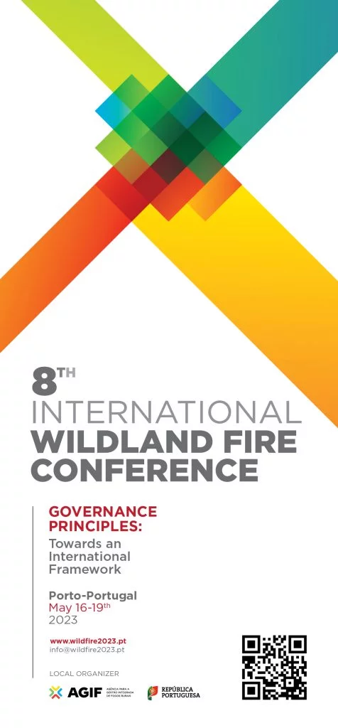
Wildfire 2023 Logo

The INTERNATIONAL WILDLAND FIRE CONFERENCE (external link), a series of conferences aimed at promoting exchange of expertise and international cooperation in wildland fire management, is held in Porto.

This year’s conference puts a special focus on integrated fire management and fire risk governance, which is exactly what our fire management platform firemaps.net was made for: informed fire management decisions, continuous learning at the landscape level, and an integrated fire management approach supported by the latest advances in Earth observation and fire science.

firemaps.net will be part of the conference as an exhibitor. We will also be be presenting our research on estimating fire intensity from space, and will be sharing perspectives about developing a strategic approach to fire information sourcing in savanna landscapes using firemaps.net.

We hope you can join us at the conference and visit us at our exhibition booth!

Fire intensity – why we need to get it right, and what we can see from space

A Sentinel 2 false colour image of fire fronts, burned areas and unburned vegetation in Comoé National Park, Côte d’Ivoire. Overlaid red dots are VIIRS fire detections a few hours after the Sentinel-2 overpass. Click to enlarge.

Fire intensity is undisputedly the most commonly used term to describe a fire in the wildfire community. Its formulation is simple, and it is quite easy to understand conceptually. The classical formulation of fire intensity was introduced by Byram in 1959 – that’s why fire intensity or fireline intensity is often called Byram’s fire intensity. Its main variables are the fire’s forward rate of spread and the fuel consumption at the fire front. Together with the vegetation’s heat content, which is more or less constant across vegetation types, its is straightforward to calculate fire intensity. Fire intensity is closely related to many other fire characteristics, such as flame height, tree scorch height, crowning, tree mortality or top-kill, smoke injection height and many others –  not least among them the safety of firefighters and civilians. In an ongoing discussion on opportunities to reduce emissions from fires over savannas in Africa and creation of carbon finance that can support conservation and local communities, fire intensity plays a key role.

And yet fire intensity remains elusive and shrouded in mystery. There is no global dataset on fire intensity and there are even relatively few field measurements. This is because it is not easy to measure – neither from space nor from the ground. It is not easy to measure fire rate of spread in the field, and it is also not easy to measure fuel consumption in the fire front. So, what fire managers usually do in the field is to estimate fire intensity from (often visual) estimations of flame length or flame height, or (after the fire) from tree scorch height. Setting up a fire experiment to actually measure fire intensity requires a substantial amount of work, is obviously not permitted or save to do everywhere and at all times, and needs measurement equipment and experience. Most experiments are small in scale, there are extremely few fire intensity measurements over (large) wildfires, measurement methods are quite variable and depend a lot on the budget and instrumentation at hand. Not surprisingly, substantially more information is available on boreal fire behaviour than about the tropics.

Another approach (also implemented in firemaps.net) is to use modelling to forecast fire intensity based on weather variables, fuel information and terrain. But then again, to assess the accuracy of a model, or even to train a model, you need observed data.

What we can see from space

Remote sensing scientists have been looking at the heat release measured through thermal infrared sensors from space and tried to relate it to fire intensity. However, this approach has its difficulties. Although the thermal signal comes in units of power (W) and – if our fire front is long and large enough to be seen by coarse resolution infrared sensors from space –  we can relate this fire radiative power to the length of the fire front, we will still end up with something termed “radiative fireline intensity”, which is very much different from fire intensity as fire managers know and appreciate it.

While the satellite observable fire radiative power (FRP) is related to the instantaneous rate of fuel consumption (i.e. kg/s), what is missing in the equation is the rate of spread.

New and upcoming sensors in space offer fresh opportunities to tackle this problem and potentially create a reference database that would give a new look on fire intensity, especially in savanna landscapes. In a recent paper, we describe a concept which is based on combining data from different satellites to both assess fire rate of spread (over a time of a few hours) and fuel consumption, which can then be combined to fire intensity.

An experimental fire in Comoé National Park

How is this done? We use data from the European Sentinel-2 Satellite to identify fire fronts active at the time of the satellite overpass at about 10 in the morning, and assess the distance the fire front moved by comparing to (coarser resolution) data delivered by the US satellites NOAA 20 and S-NPP about two and a half hours later. During this time, the European weather staellite Meteosat keeps taking images of the fire every 15 minutes (at coarse spatial resolution), recording the heat release (FRP) of the fire. This heat release can then be converted to fuel consumption. Combining these two measurements, we get fire intensity. To our knowledge, this is the first time that genuine fire intensity has been measured from space.

However, we have just obtained a small sample of what is going on in the landscape, and Sentinel-2 data are only available every five days. When observing frequently burning landscapes such as African savannas, this approach may still give a sufficiently large sample to characterize fire intensity regimes at landscape level and to gauge remote sensing derived fire intensities against model outcomes or ground measurements. In the light of the ongoing discussion on changing fire regimes in Africa to reduce greenhouse gas emissions, enhance biodiversity and generate carbon revenues, having an actual measure of fire intensity could help testing assumptions that early season burns will be less intensive than late season burns, and thus cause less emissions. Thus, better knowledge of fire intensity may support better decisions in conserving biodiversity and mitigating climate change.

firemaps.net app released soon

Fires happen outside. This is why you’ll want to take current fire information with you to manage fires, check burned areas and stay safe. The firemaps.net mobile app lets you take firemaps to the field.

Configurable mobile content can include latest satellite image, latest fire detections, fire model predictions, burned areas and more. The app can support you to:
  • Record management activities in real time. Sync back to the server to share latest information from the ground with your team.
  • See your position in relation to the latest active fire detections
  • See your position in relation to predicted fire spread (with the online fire modelling tool).
  • Check the burned area maps on the ground and assess damage.
 
Can’t wait to try it out? Sign up today on firemaps.net to become a beta user of the app.

Monitor and reduce greenhouse gas emissions from fires – new whitepaper

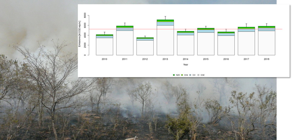
Managing and reducing emissons from controlled burns and wildfires is an increasingly important objective in fire management. Emissions from fires influence the global climate and affect the environment and human health. Projects aiming at reducing emissions may qualify for climate mitigation finance, provided that they can actually prove a reduction of emissions. Knowledge about the fire history and a baseline of fire emissions, as well as efficient and reliable monitoring is therefore the key to success.

In a new white paper, we describe the methods used for estimating smoke emissions from fires in firemaps.net and show how practical applications for reducing greenhouse gas emissions from fire can be implemented using the tools provided by firemaps.net. Our method is based on direct observation of the actively burning fire using satellites observing Earth with infrared sensors. These sensors are able to measure the heat emitted from fires. The amount of heat released during a fire is proportional to the amount of biomass burned, and biomass burned in turn is proportional to emissions of greenhouse gases and other smoke constituents.  Using this method therefore offers an opportunity for directly deriving fuel consumption and emissions from remote sensing data. The paper describes the estimation model and data used to derive fuel consumption from multiple satellite observations of active fires and burned areas, and the conversion of fuel consumption to smoke emissions. A comparison to field data is also provided. A detailed discussion of the achieved accuracy and sources of uncertainties is provided in the annex. In the concluding part of the white paper we describe practical applications with a focus on savanna ecosystems, first discussing the role of fire and CO2 and Non-CO2 greenhouse gas fluxes in savannas. A good understanding of fire regimes in potential project areas is required to plan for mitigation projects.  Hence the role of establishing a fire emissions baseline for planning of emission reduction activities is described. Shifting of burning patterns has been shown to be an option to achieve reductions in fire emissions. We show how this can be planned, implemented and documented in firemaps.net with examples from West Africa and Brazil. Apart from directly reducing fire emissions, improved fire management, e.g. through using prescribed burning, can also help to increase carbon stocks when fire intensities are managed. How this can be done will be a key topic in a forthcoming white paper. Finally we point out how firemaps.net information products can help building a proposal to acquire funding through mechanisms such as the green climate fund.

Get the white paper (You may need to login or register).

firemaps.net wins the Copernicus Masters DLR Environment and Health Challenge

Yesterday, we have been awarded the prestigious Copernicus Masters DLR Environment and Health Challenge Price! The award ceremony took place during the European Space Week in Tallinn, Estonia.

This is what jury member Dr. Doris Klein (scientific coordinator of the DLR FireBird project) says about firemaps.net:

«Information about fire is relevant for many aspects – ranging from human security to ecosystem management. firemaps.net shows how remote sensing data can be transformed into fire information. By providing this information in a user friendly way to environmental managers, it enables them to make informed decisions and to reduce negative impacts from bush and savanna fires, such as greenhouse gas emissions or damages to trees.»

Receiving this prize makes us proud about what we already achieved so far and motivates us for the next steps and new features we are currently busily implementing. Thanks go to the jury and to DLR, the sponsors of the price, and thanks go to the European Commission for investing in observing planet Earth with the Sentinel satellite fleet! The Sentinel open data policy makes the development of services such as ours possible.


firemaps.net at the 37th International Symposium for Remote Sensing of Environment

Discover firemaps.net at the 37th International Symposium for Remote Sensing of Envrionment (ISRSE) in South Africa.

The 37th edition of ISRSE will convene in Tshwane, South Africa 8 to 12 May 2017. The theme is “Earth Observation for Development and Adaptation to a Changing World”.

This will be the second time in this millennium that the African continent will host ISRSE. The event takes place at a time of rapid development in the African space science and technology sector. We have been active on the African continent in recent projects supporting fire monitoring in Tanzania, in transfrontier National Parks in South Africa and Mozambique, and are currently supporting fire management in the World Heritage Site Comoé National Park in Ivory Coast. Have a look at our maps on over ten years of biomass burning and emissions data for South Africa here

Find out more on ISRSE37 on this external link.

Apart from presenting firemaps.net at our booth (number 23) at ISRSE, we report on our latest work in the wildfire session on Thursday 9th May under the title “Analyzing fire behavior from space using high and medium resolution IR sensors”. More hot stuff is shown in our talk “detecting and analyzing gas flares using Sentinel 3 and FireBird” in the session on greenhouse gases on Wednesday 10th March.


fires in the news – Spain, summer 2016

While Spain is experiencing a record tourist season in 2016, it is also suffering a record year in forest and bush fires. And these make it to the (international) news more easily, when tourists and fires come together, as has happened in the Spanish province of Alicante near the beach resort of Benidorm. Hundreds of residents, and many tourists, had to be evacuated, as fires (probably ignited by arsonists) ravaged near the location of Javea.

Read morefires in the news – Spain, summer 2016

what firemaps.net is about

firemaps.net provides you with fire monitoring information from space.

We support fire management planning through information on burned area, fuel consumption, biomass burned and emissions of greenhouse gases and other smoke constituents, as well as on the timing of the fires. We derive this information from burned area datasets and from observations of the burning fires through infrared sensors such as MODIS.

Read morewhat firemaps.net is about